Phone call began process to open prime elk hunting area off Cow Island Trail


April 27, 2016

Steve Edwards

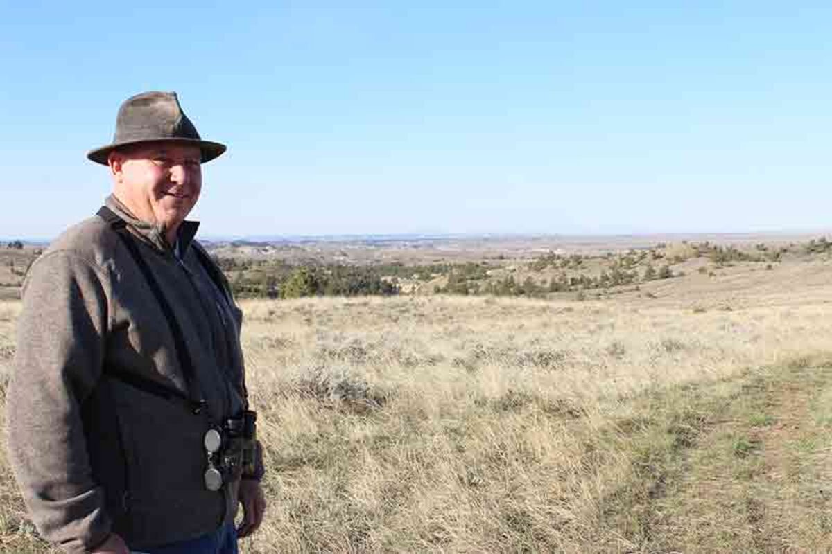
Mike Bryson looks over the area now made accessible to hunters after a purchase of a 93-acre tract adjacent to Cow Island Trail in south Blaine County. The tract allows access to a state section that ultimately opens about 6,000 acres of public land to hunters. The area is considered prime habitat for elk and bighorn sheep as well as other big game species.

Reporter's note: Someone left a copy of the March-April, 2016 "Bugle" magazine on my desk at the newspaper office. The magazine is the official publication of the Rocky Mountain Elk Foundation (RMEF). Not being an elk hunter I wasn't familiar with the publication, but an article titled "A New Fork on the Cow Island Trail" caught my eye. I recognized the road name because of some previous public land access stories I'd written.

The story was about the purchase of a 93-acre tract of land, by the Rocky Mountain Elk Foundation, that opened up "more than 6,000 acres of great elk country above the northwestern tip of the Missouri Breaks." A phone call from a local hunting enthusiast, Mike Bryson of Chinook, got RMEF interested in acquiring the land. This story describes how the process got started to purchase the land and what it means for hunters in the area about 60 miles south of Chinook.


Access for hunting on public land

After a brief visit with Mike Bryson, he said, "The best way to understand what this land purchase is all about, we should drive down and take a look at it." On a sunny spring morning we headed south from Chinook on Cleveland Road, took the Lloyd Road turnoff and headed to the point where Lloyd Road intersects Cow Island Trail Road.

On the ride down Bryson told how, as a youngster, he hunted many of the areas we were passing. He explained, "Back then most ranchers, if properly asked, would give hunters access to private land. From the private land a hunter could also move on to public land which is open to hunting. Over the years that all changed." Bryson added, "Unfortunately, some disrespectful hunters caused access to be limited for everyone. Those few left gates open, tore up the land with motorized vehicles and left trash on the land. It takes this land a long time to heal from that kind of abuse. The ranchers began to limit access for hunting on their land and thought often to shut off access to nearby public lands."


After about 60 miles of travel, we were approaching the new access resulting from the purchase by RMEF. Taking the "west" turn from Lloyd Road on to Cow Island Trail, we went about five miles, through mostly open country, where Bryson pointed ahead and said, "The access is right by that set of corrals on the south side of the road."

Just past the corrals is a sign, recently erected, noting "Access provided by RMEF and BLM." The 93-acre tract, allowing access to a state section further south, is adjacent to the Cow Island Trail. Turning south, we followed the access road, through several small drainages and over some low hills to the dead end and a small dirt parking area-at a fence to private land. On the right is the state section that provides access to a vast area of rolling hills, drainages and small forested tracts that eventually lead to the Missouri Breaks. The cliff banks of the Missouri River are visible with Square Butte to the south and the Highwood Mountains along the southwest horizon. From there hunters can access, by foot or on horseback, about 6,000 acres of prime elk and bighorn sheep habitat.


Connecting to the elk habitat

The story of how the RMEF came to acquire the tract for access started when Mike met his brother, Gary, and sister-in-law, Pam, for lunch in Malta. That's midway between Mike's home in Chinook and his brother's place at Fort Peck. After lunch, Pam pulled out a real estate brochure she'd picked up at a gas stop in Glasgow. The brochure had an ad for a tract of 'rangeland' on Cow Island Trail. All three new the area, having hunted the south country over the years, and knew it was a 'gateway' to a large amount of public land. They discussed buying the land but decided they couldn't justify the expense.

A few days later, Mike Bryson recalled reading about the RMEF's Red Hill project, a purchase of a private 40-acre tract south of Lewistown, that opened up access to thousands of acres of national forest lands. He called Mike Mueller, RMEF's Senior Lands Program Manager based in Missoula, and described the tract and the kind of access it could provide. Mike added, "I called RMEF on a Thursday and Mike Mueller was in the realtor's office the next Monday." Six months later the land purchase was completed, with cooperation by the Bureau of Land Management and Montana's Fish, Wildlife and Parks department.

In the "Bugle" article about the Cow Island Trail tract, Mueller described how RMEF's focus has changed. He said, "Historically, the Elk Foundation likes to do the largest, landscape-level acquisition projects, because elk need big country. But now our focus is changing. It's more laser, and we're looking for smaller acquisitions that can provide big, big gates into public lands." He added, "The Elk Foundation is looking to make a big difference through projects like Red Hill, Cow Island Trail and similar acquisitions."

The "Bugle" article goes on to explain how the BLM had been exploring ways to provide access to public land, but the costs of road building and purchasing more land was too high for their resources. The proposal presented by RMEF was a welcome prospect and the BLM reached out to surrounding land owners to make the project was doable. Stanley James, field manager for the BLM's Havre office, said most landowners were supportive of the idea and saw the benefit of hunters having more access without crossing private land.

What's next?

The RMEF used its Torstenson Family Endowment and a donation from the Cinnabar Foundation to make the purchase. The RMEF will sell the land to the BLM who will permanently manage the parcel. That sale is likely to happen in 2016, after Congress re-authorized the Land and Water Conservation Fund for a three- year window. BLM will receive funds for the purchase of Sportsman/Recreational areas, which includes land projects exactly like the Cow Island Trail. There are already plans to install a 40-inch pedestrian gate for easier access at the southern point of land.

Steve Edwards

This sign, about five miles west of the intersection of Lloyd Road and Cow Island Trail, identifies the public access road to a state section. From the state section hunters will be able to access about 6,000 acres of elk habitat previously not accessible except through private land.

At the tract, gazing over the areas opened up by the tract purchase, Mike Bryson said, "This is a good place to sit and glass the area, looking for signs of elk." He pointed to a closer depression and added, "And that is a great place to find bighorn sheep." Bryson was already making plans to "bring my camper to the parking area and spend some time just watching for what I might see." It was obvious he was very glad he made that call.


Powered by ROAR Online Publication Software from Lions Light Corporation
© Copyright 2024