Why the Missouri River used to run north of the Bear Paws
July 8, 2020

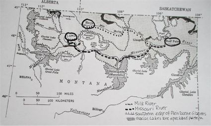
This graphic shows the locations of the southern edges of the glacial sheets and glacial lakes that covered much of north central Montana 100,000+ years ago. The map also shows the present-day route of the Milk (dots) and Missouri (dashes) Rivers. The pre-glacial route of the Missouri River was around the north edge of the Bear Paws and through Blaine County along a channel now occupied by the Milk River.
Several weeks ago my wife and I were returning from a trip to the Fort Peck area. Drivers who've made that trip know there are not many places to take a break between Glasgow and Malta. We remembered a state rest area located about halfway between Hinsdale and Glasgow and decided to make a quick pit stop there on our way back home to Chinook.
While waiting for my wife I began reading the informational sign at the rest stop that gave some information about the area. I was surprised to read that the area was covered by glaciers during several different periods through the centuries (per glac...
For access to this article please
sign in or
subscribe.


